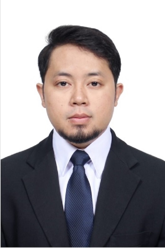
メンバー/Members

教員

泉 佑太 助教
Assistant Professor Yuta Izumi, Ph.D

Yuta Izumi received his B. Eng and M. Eng from Chiba University, Japan, in 2016, and 2018, respectively (supervised by Prof. Josaphat Tetuko Sri Sumantyo), and his Ph.D in radar remote sensing from Tohoku University, Japan, in 2021 (supervised by Prof. Emer. Motoyuki Sato). From 2018 to 2020, he was a JSPS research fellow DC1. From 2019 to 2020, he stayed at the Swiss Federal Institute of Technology (ETH) Zurich, Switzerland. From 2021 to 2022, he was a JSPS research fellow (postdoctoral) at the Institute of Industrial Science, the University of Tokyo (at Wataru Takeuchi lab.). He is currently an assistant professor at Muroran Institute of Technology. His research interests include SAR interferometry and polarimetry and their applications for disaster mitigation and infrastructure health monitoring.

客員研究員 Visiting Researcher

Dr. Dandy Aditya Novresiandi (Badan Riset dan Inovasi Nasional (BRIN))

共同研究員 Collaborative Researcher

Dr. Joko Widodo

博士 Doctor

D1

Fathin Nurzaman

Currently researching about Ground-Based SAR’s data processing and applications.
I have a master’s degree in Geodesy and Geomatics Engineering. I have some experience on:
Satellite altimetry
SAR (Synthetic Aperture Radar)
GIS (Geographic Information System)
GNSS
Programming (Matlab, Fortran, and Python)
Advanced data analysis
I’m very open to discussion. Feel free to contact me 🙂
現在、地上ベースの SAR のデータ処理とアプリケーションについて研究しています。
私は測地学と地理情報工学の修士号を取得しています。以下の分野での経験があります:
衛星高度測定
SAR (合成開口レーダー)
GIS (地理情報システム)
GNSS
プログラミング (Matlab、Fortran、Python)
高度なデータ分析
私は議論を歓迎します。お気軽にご連絡ください。:)

Sartika

Studies on MIMO Radar for infrastructure monitoring, currently focused on developing a new method for discontinuous monitoring. The research interest is in remote sensing image processing.

Qoriatu Zahro

My PhD research utilizes spaceborn SAR product with interferometry approach to evaluate earth surface displacement especially in densely vegetated area. I explore timeseries L-band and C-band data with PS and DS method to find best-fit approach to investigate earth’s surface changes. For case study, I observe surface displacement of peatland in the context of restoration evaluation.
I completed my Master degree in Geography through a sandwich program in Gadjah Mada University Indonesia with Leibniz Zentrum für Marine Tropenforschung ZMT in Bremen University, specializing in coastal and watershed management and planning. My master thesis explored the interconnection between land cover changes in the catchment area of Segara Anakan Lagoon (Java, Indonesia) and non-physical aspects within the region.
Email :

修士 Master

M2

石垣諒太

ドローンに搭載型合成開口レーダの開発を行っています。
将来的には機動的・高頻度な観測の実現を目指します。
I am developing a drone-borne synthetic aperture radar.
The goal is to realize flexible and frequent observations.

伊藤太一

MIMOレーダ
複数の送受信アンテナで構成されるMIMOレーダは,レーダシステム自体を機械的に動かさずとも合成開口処理をすることができる.
MIMO radar, which consists of multiple transmitting and receiving antennas, can perform SAR processing without mechanically moving the radar system itself.
橋梁計測
MIMOレーダは従来のGB-SARよりもはるかに高速でデータを取得することができる.その特性から列車やトラックが通過することによって発生する橋梁の変位および振動を計測することができる.
The data acquisition rate of MIMO radar is much faster than the conventional GB-SAR. The displacement and vibration of bridges caused by trains and trucks passing over them can be measured.

M1

浦野孔希

私は、地上設置型合成開口レーダ(GBSAR)を用いた時系列InSAR解析の研究を行っています。また、積雪状況に対するSAR画像情報の解析を偏波データを基に行っています。
I am conducting research on time-series InSAR analysis using ground-based synthetic aperture radar (GBSAR). I am also analyzing SAR image information for snow cover conditions based on polarimetric data.

石井大翔(川村研)

石川凌(川村研)

合成開口レーダを用いた土壌水分の推定について研究しています。対象地は胆振東部地震で崩壊した日高幌内川流域の自然斜面です。
現地計測を行っているため、そのデータと合成開口レーダの解析結果を比較することで実用性を検証しています。
合成開口レーダで土壌水分を推定することができれば、早期またピンポイントの避難等に繋げることができると考えています。
I am working on estimating soil moisture using synthetic aperture radar.
The target area is the natural slope of the Hidaka Horonai River basin that collapsed due to the East Iburi Earthquake.
Since field measurements are being made, the practicality is verified by comparing the data with the results of SAR analysis.
If we can estimate soil moisture using synthetic aperture radar, we will be able to evacuate people earlier and with pinpoint accuracy.

鈴木健心(川村研)

合成開口レーダー(SAR)を用いて、壮瞥町は長流川流域に分布する地すべり斜面の変動解析を行う。解析による変形挙動から地すべり斜面の安定性評価法を新たに提案し、有限要素法による既存の安定性評価法との比較を行い、整合性を図る。
人工衛星Sentinel-1による広範囲の変動解析と並行して、地上設置型合成開口レーダー(GB-SAR)による一斜面の集中的な変動解析を行う。さらに、GB-SAR実地観測において生じる誤差について検討し、誤差を測定する方法を検討する。
Using Synthetic Aperture Radar (SAR), we analyze the deformation of landslide slopes in the Nagaregawa River basin in Sobetsu Town, Hokkaido. A new stability evaluation method for landslide slopes is proposed based on the analytical deformation behavior, and compared with the existing stability evaluation method using the finite element method to confirm consistency.
In parallel with the wide-area deformation analysis using the Sentinel-1 satellite, we will conduct intensive deformation analysis of a single slope using the ground-based synthetic aperture radar (GB-SAR). In addition, we will examine the errors that occur in GB-SAR field observations and investigate methods to measure the errors.

学部 Undergraduate

B4

阿部裕貴

2023年~2024年の冬に大学構内の敷地で積雪の実測値を記録しました。
GB-SARにおいて記録されたデータを解析し実測値との比較を行います。
Actual snowfall measurements were recorded on the university campus in the winter of 2023-2024. The data recorded by GB-SAR will be analyzed and compared with the actual measurements.

伊藤大智

私の研究内容は衛星に搭載された合成開口レーダ(SAR)を用いたインフラモニタリングの時系列変位の解析です。
札幌市北部の道路のうねりを直近3年間のデータを用いて時系列変位の解析を行っております。衛星はSentinel-1を用いて解析を行っております。
My research involves analyzing time-series displacements for infrastructure monitoring using Synthetic Aperture Radar (SAR) mounted on satellites.
I am analyzing the time-series displacements of road undulations in the northern part of Sapporo City using data from the past three years. I am using the Sentinel-1 satellite for this analysis.

小山有真

GB-SAR(地上設置型合成開口レーダ)で、道内の地滑りが発生した地点の観測と、観測データの解析を行っています。使用しているレーダは、ミリ単位の変位も検出可能で、最大4Km先まで観測することができる性能を有しています。地滑りの観測は定期的に行っており、時系列で変位を確認することができます。
My research theme is the observation of landslide sites using GB-SAR (Ground Based Synthetic Aperture Rador) and the analysis of the data in Hokkaido. We use a radar that is able to detect displacements in the millimeter range and has the ability to observe up to 4 km away.Since the observations are made routinely, the displacement can be seen as time-series data.

義盛幸多

ドローン搭載型合成開口レーダを用いた変位計測に関する研究を行っています。
I study on displacement monitoring methodology by drone-borne SAR.

竹内郁人(川村研)